


-

"Very nice Posters. The quality is amazing and we received it very quickly !"
-

"A shop to visit absolutely. Huge selection of posters. We spent more than an hour there !"
-

"Perfect to find gift. Price are very good. An they can frame and pack it on site"


About the Artist
Friedrich Wilhelm Putzger was a German educator and cartographic editor renowned for his influential school atlases in the late nineteenth and early twentieth centuries. His commitment to clarity and precision helped shape the way generations of students visualized geography and astronomy, making complex subjects accessible through thoughtful design.
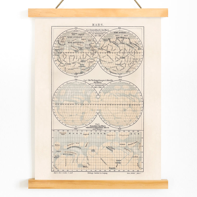
This Map of Mars from 1908 was produced during a period of intense interest in planetary science, as advances in telescopic observation sparked widespread curiosity about the Red Planet. Putzger’s work reflects the era’s drive to compile and communicate new astronomical findings to a broad audience.
The Artwork
At the dawn of the twentieth century, Mars was a subject of fascination and speculation, with scientists and the public alike captivated by its mysterious surface features. This map was created to consolidate contemporary observations, serving as a reference for atlases and encyclopedias and embodying the spirit of scientific inquiry of its time.
Produced in an age of systematic cataloging, the map illustrates how knowledge of distant worlds was assembled and shared. It stands as a testament to the intersection of discovery and imagination, offering a historical snapshot of early planetary cartography.
Style & Characteristics
The map centers on a circular depiction of Mars, structured by a meticulous coordinate grid and dense, legible labeling. Delicate black linework and compact type create an archival, reference-plate aesthetic, balancing informational clarity with visual order.
Rendered in understated beige and black, the composition exudes a calm, scholarly mood. Its blend of scientific illustration and decorative appeal makes it a compelling choice for those drawn to vintage space maps and classic cartographic art. For related works, explore vintage maps wall art, space posters and prints, or scientific illustration prints.
In Interior Design
This Mars map vintage print lends a refined, intellectual touch to home offices, studies, or libraries, where its academic character pairs well with books, wood, and leather. It also complements modern interiors as a subtle conversation piece, especially within a gallery of scientific charts.
For a cohesive look, combine it with warm neutrals, walnut, brass, or minimalist black frames and crisp white mats.